Your group, your route, even off the grid.
Offline maps, GPS tracking, and mesh radio so your group stays connected miles past the last cell tower. Check river levels, see where your friends are, and text each other with no signal required.
Free · Passwordless sign-in · iOS & Android
How the mesh works
Pair a LoRa radio with your phone over Bluetooth. Your location and messages hop between devices, no internet needed.
Clip on a radio
Any MeshCore-compatible LoRa radio pairs over Bluetooth in seconds.
Share your position
Your GPS fix broadcasts to the group automatically while you record a trip.
Text & track offline
Send short messages, see everyone on the map, and follow their trail, all through the mesh.
Built for the backcountry
Everything works offline. Everything syncs when you're back.
Offline map packs
Download an area before you head out. Topo, satellite, trails, and river gauges all stored on your phone. No signal? No problem.
See your group on the map
Friends show up as live markers with speed, heading, and distance. Track each other on the river or the trail, even without cell service.
Mesh radio texting
Pair a LoRa radio and send short messages to the group when there's no cell tower for miles. Encrypted, signed, and delivered through the mesh.
River levels & flow
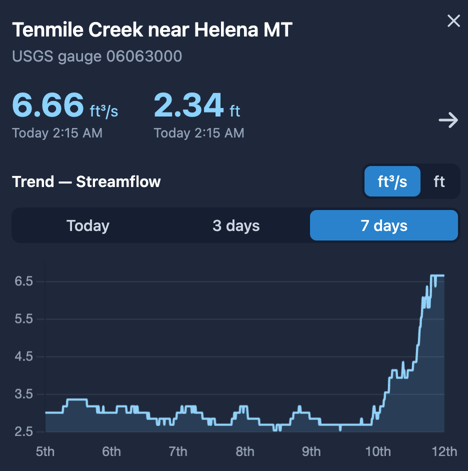
Real-time USGS streamflow and gage height with 7-day trends. Know what's coming before you're on the water.
Trails & OHV routes
Hiking, biking, and motorized routes from the U.S. Forest Service and OpenStreetMap. Find the right trail for your trip.
GPS trip recording
Track your paddle, ride, or hike. Save your route, share it, and look back at where you've been.
Public lands & access
Wildlife management areas, fishing access sites, parcels, and recreation facilities, layered onto the same map.
Group SOS signal
Flag your position to everyone in your radio group with one tap. Your group sees you're in trouble and where you are, even with no cell coverage.
Private & free
Passwordless sign-in, end-to-end encrypted radio, built on free public data. No tracking, no clutter.
See the river before you're in it.
Live streamflow and gage height from thousands of USGS gauges. Check the trend, know the level, and make the call with real data, not guesswork at the put-in.
- ✓ Streamflow (CFS) and gage height with 7-day charts
- ✓ Gauge markers right on the map, tap for details
- ✓ Download the river corridor so it works offline
- ✓ Track your paddle and share it with the group
Nobody gets lost.
Start a trip and your group appears on the map. See each other's position, speed, and heading in real time. Text through the mesh when the bars drop. Follow their breadcrumb trail if you fall behind.
- ✓ Live position markers with name, speed, and distance
- ✓ Breadcrumb trails show where everyone has been
- ✓ Mesh texting works with zero cell coverage
- ✓ Share a trip link or QR code to bring people in
Powered by trusted public data
All sourced from free, public data. Conditions are provisional, always check official sources and use good judgment in the field.
Get outside with your people.
Download the area, bring a radio, and know where everyone is, even when the bars are gone.